Operations
Fuel Estimation
TOPCAT provides a very basic fuel calculation
for the planned flight. No doubts the result might
not as accurate than the fuel calculation performed
with tools dedicated to do this job. It does not
consider winds aloft and the route is more or less
great circle. However, I remember only a few cases
were I was short of fuel, e.g. caused by a strong
head wind component.
Take-Off Report
The Take-Off report supplies the pilot with all
relevant data for the planned take-off. The snap
below shows cut of that report.
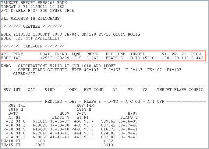
Snap from the TOPCAT Take-OFF report
For the complete report click 'here'.
Assumed Temperature
If the given take-off conditions (aircraft, runway,
obstacle, ...) are sufficient for reduced take-off
performance I usually take this option. In real life
this saves the airline companies costs for engine
maintenance and Increases the engines life time.
Well, this of course is not really relevant for
flight simulator operations, but helps to understand
real operations better and gives a nice longer
take-off run.
The setting of the take-off thrust is done by entering a temperature higher than the actual outside air temperature as OAT at the CDU N1 LIMIT page.
The V-speeds (V1, VR, V2) are entered on the on TAKEOFF REF page of the CDU.
In the example above the maximum assumed temperature with a planned take-off weight (PTOW) of 61,443kg would be 58 degree centigrade, limited by obstacles.
Another method for trust reduction is called 'Fixed Derate'. TOPCAT supports this method as well, also in combination with the 'Assumed Temperature' method.
OAT
(Outside
Air Temperature)
V-speeds (http://en.wikipedia.org/wiki/V_speeds)
Landing Report
The TOPCAT landing report provides the following
information: weather, dispatch limits, required
landing distance (both normal and low visibility),
and autobrake landing distance.
Click 'here'
for a landing report example.
Links:
TOPCAT:
http://www.topcatsim.com/
Nav Data and Charts
For on-line flying in one of the networks it is
essential to have valid Nav data for the FMC,
airport charts, and enroute charts (ATS Routes).
Navigraph is publishing every 28 days a new AIRAC
cycle for FMC nav data. The Navigraph data are available
in different formats for all major aircraft add-on's and system suits
as well,
such as Project Magenta or Prosim737.
Other sources for charts are:
- IVAO
- European AIS Database’s (EAD)
- VatSIM
All of the above 'other sources' free of charge. For EAD and IVAO an user account is necessary.
AIRAC = Aeronautical Information Regulation and Control